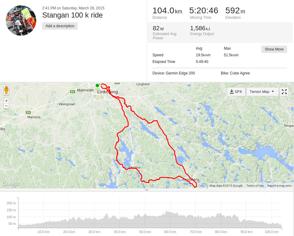
First 100k ride in Sweden in 2015
My first 100 k ride this year was the Anchetty 200 BRM that I attempted and finished, albeit without homologation, on my trip to India. The weather in Sweden hadn't been exactly conducive for longer rides and when it had, I hadn't been out much. I finally decided to shake off my lethargy and head out for a 100 k ride yesterday. The weather was splendid, but I was already well past noon and I was wondering about the light. Another unknown element was the actual route, along the Stångån, across Hackefors, Atvidaberg, Bestorp and back. I hadn't done this route earlier and I'd only ridden till Hackefors and didn't really know the nature of the roads past that point, but I guessed it'd be fine. I'd made two versions of this route, a shorter 65 k route and the longer 104 k route and both of them were on my Garmin. When I finally started off, equipped with water, bananas and some electrolyte, I decided to take on the longer route, cutting it shorter, if need be. I carried a couple of extra inner tubes and a pair of tire levers, but failed to add my multi-tool with Allen keys to the mix, and this would come back to bite me, and hard.
I started off on a song. The weather was near perfect and the wind very light. I flew on for a while, not even having to look at the GPS, pretty much all the way till Skonbergavägen, as I'd done that ride on my Fixie. I passed Hackefors, not long after that. As I neared Sörby, I got my first unpleasant surprise when I realized that it was a fairly rough road, strewn with rocks. It wasn't exactly mountain-bike rough, but it was definitely not road bike safe either. I had to drop all my pace to ensure that I didn't damage my bike or pick up a puncture on the sharp stones, and it lasted for five long kilometers!! I knew it couldn't all be bad, but each time I crested a rise and saw more of the same surface, I felt worse. I'd created the map on garmin.com where there is no option to use Google Street View. Map creation on strava provides Street View, but is slightly more cumbersome otherwise, than on garmin.com. Next time, I'll either make it on strava, or upload the garmin route to strava and inspect it with Street View, to ensure that the terrain is ok. As soon as that horror stretch ended, I was overjoyed and quickly picked up the pace. I was however on the state highway 35 (which is another thing that was not clear on garmin.com, but was fairly obvious, on strava) and had to be extra careful, to stay clear of the fast moving traffic. The road was a series of climbs and descents and one descent, I hit a top speed of 51.5 kmph, the fastest speed I've touched while biking since last year's Vatternrundan, when I clocked 58.0 kmph :) I was also looking at my heartrate and cadence. I could see that I was doing well, before I started feeling the first signs of pain in my right knee. This was something I'd suffered before, on the Roxen Runt and knew straightaway that the saddle height was a tad too high. I hadn't ridden the bike on longer rides in a long time and I'd possibly fiddled around with the saddle height sometime last year and forgotten about. I got down to adjust it and then smacked my head when I realized that the seatpost on my roadbike can only be adjusted with an Allen key and I didn't have my Allen set with me. This meant that I had to push on. I'd also rounded the bend after Atvidaberg, meaning that I'd passed the half-way mark; I no longer had any option of cutting the ride short; I had to finish.
I pushed on, but at a reduced pace, and each time I came to a rise, I was careful to not put my distressed right knee to any more work than it had to do. On flatter stretches, I spun with a totally different gear combo that increased comfort at the cost of speed, at a lower cadence. Prior to the onset of pain, I was pushing at 75-95 RPM, but now, I was not going above 50, but the knee continued to suffer, particularly when I had to take on a bunch of short climbs. I had plenty of water, electrolyte and even a banana, so hydration would not be a problem, and I had an excellent 'to see' light, apart from the regular 'to be seen' light, so I would be ok after sundown. As I closed in on Bestorp, I realized that I would have to go through a second stretch of horrible uncemented road with sharp stones. In all this, I was determined not to waste time, so I kept my stops very brief and kept pushing. If the going had been tough till then, I found to my dismay that the temperature dropped very quickly, after sundown, and my bicycle shoes were doing nothing to keep my feet and toes warm. I was trying my best to keep wiggling my toes, to keep them from going completely numb. The last thirty kilometers were really hard and I gave up all attempts to keep up my average speed, my only focus being on completing the ride and getting back home in one piece! I reached home at least at 2030 hrs local time, five hours and fifty minutes after I'd started, exhausted by satisfied. I'm particularly happy that despite all of the pain, I was only stationary for 20 minutes for the entire distance. I've now modified this route to eliminate the bad stretches and also the ride on the state highway and look forward to riding that route soon.